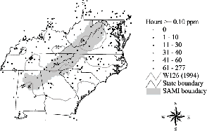
 The W126 ozone levels predicted at
0.5 degree grids are shown to the right. The map was prepared
using kriging interpolation previously performed by A.S.L. &
Associates for the 8 states for the period 1990-1995. For each
of the years, the actual N100 values were plotted on the same
maps. The figure is an example that shows the ambient exposures
for the study region.
The W126 ozone levels predicted at
0.5 degree grids are shown to the right. The map was prepared
using kriging interpolation previously performed by A.S.L. &
Associates for the 8 states for the period 1990-1995. For each
of the years, the actual N100 values were plotted on the same
maps. The figure is an example that shows the ambient exposures
for the study region.